NOAA's New Daily Sargassum Tracker Could Be a Game Changer for Puerto Morelos |
Enter Subtitle |
Scientists say 2026 could be a record year for sargassum along the Mexican Caribbean. But now, for the first time, you can check the risk every single day before you head to the beach.
NOAA Just Made Its Tracking Tool Much Better
NOAA's Sargassum Inundation Risk tool, known as the SIR, has been upgraded to offer daily reports on the location and risk that brown floating algae could wash ashore along coastal areas in the Caribbean, Florida, and northern South America. That is a big deal.
The SIR now provides a daily report with a resolution of approximately half a mile, or one kilometer. Previously, these reports were issued weekly with a resolution of three miles, or five kilometers.
In plain terms, the new tool is seven times more detailed and updated seven times more often.
NOAA is now monitoring large masses of sargassum moving across the Atlantic Ocean. You can check the daily maps yourself at NOAA's Atlantic Oceanographic and Meteorological Laboratory website.
2026 Is Shaping Up to Be a Serious Year
Scientists are not sugarcoating it. Early 2026 sargassum volumes in the central Atlantic are tracking higher than recent years, with the season starting earlier than usual in some areas.
What Puerto Morelos Is Doing About It
Local and state authorities are not sitting on their hands. Authorities are working to protect Puerto Morelos beaches given forecasts of sargassum for 2026.
Local and state authorities, including the Navy, are deploying seaweed barriers, vessels, and collection strategies along the coast, including Puerto Morelos, to intercept sargassum before it reaches the shore.
Why It Matters Beyond the Smell
Yes, the smell is bad. Rotting sargassum on the beach releases hydrogen sulfide gas, which smells like rotten eggs.
Exposure to hydrogen sulfide produced by decomposing sargassum may cause respiratory and cardiovascular problems, particularly for sensitive populations like children, the elderly, and those with existing health conditions.
Beyond health, there are real environmental concerns too. Decaying sargassum can interfere with sea turtle nesting and contribute to low oxygen levels in coastal waters, which can harm fish and other marine life.
How to Use the New Tool
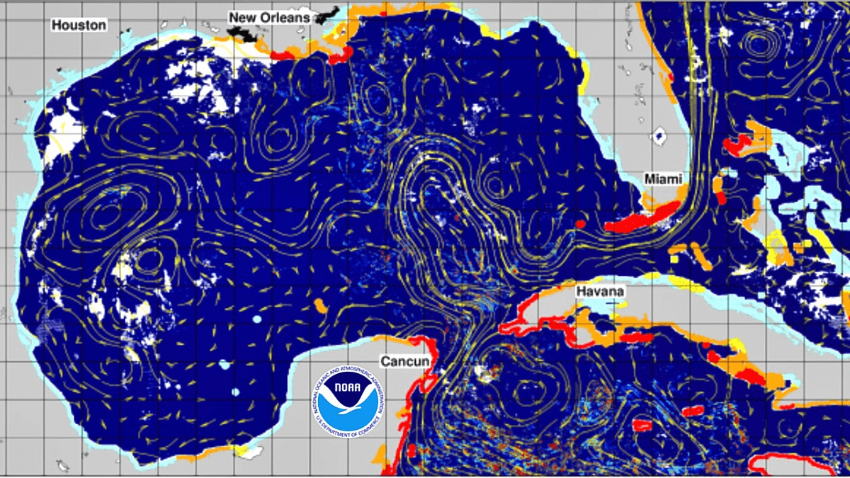
The NOAA SIR maps use color-coded risk levels: blue for low, yellow for warning, orange for medium, and red for high.
The maps are updated daily and cover the Gulf of Mexico, Central America, the Greater and Lesser Antilles, and South America.
Bookmark the tool at aoml.noaa.gov and check it before heading to the beach, planning a fishing trip, or booking guests. |
0 Comments
Join the conversation
Be the first to comment
Share your thoughts above.